Bird by Bird: The App that’s Elevating Citizen Scientists to New Heights
CLIENT
![]()
SERVICES
Custom development, Mobile App development
PLATFORMS
Mobile Application for iOS and Android
About the client
Birds Canada is a non-profit, charitable organization that cares deeply about the ongoing well-being and conservation of birds living in Canada. Through sound science, on-the-ground actions, innovative partnerships, public engagement, and science-based advocacy, Birds Canada educates and engages researchers, birders, nature enthusiasts and the caring public in the current and future state of our bird population.
Birds Canada has engaged nearly 70,000 Canadian volunteers as Citizen Scientists for one or more of Birds Canada’s programs, keeping an eye on the health of bird populations.
Project overview
Birds Canada came to Punchcard in 2019 to figure out how we could improve the experience and data quality for Citizen Scientists and professional scientists and field biologists who participate in their projects. They believed that a custom mobile app would enable them to:
- Allow for direct data entry while doing surveys.
- Provide real-time feedback on errors to improve data quality and accuracy.
- Collect data offline more easily than their current paper form system and web based system.
- Pinpoint a bird’s specific location with a user’s mobile GPS.
- Give users the most up-to-date list of birds in their area.
They also believed that improving the experience for participants would increase the overall participation in their projects, and result in better research.
Problem statement
In 2019, the existing mobile apps for birding were more generic in nature, and did not support the full range of birding protocols Birds Canada would require for their research projects. The apps also felt limited in their functionality, and would not be suitable long-term solutions.
To start our thinking, we worked with Birds Canada to draft the following problem statement:
Most existing field study tools are web-enabled, with limited support for mobile or offline data entry. How might we build a mobile platform to allow Citizen Scientists, professional field biologists, and researchers to capture field data in real time, which could support various research projects?
The solution
Birds Canada conducts multiple research studies over the course of one or multiple years. Their research requires different data to be collected and analyzed, and those projects could vary depending on their priorities at a given time.
The decision to build a mobile app was simple—the difficulty came with understanding the unique requirements of typical research projects and how those projects might require different types of data points.
We started with a minimum viable product (MVP) so that we could start collecting survey data. For this first version, we prioritized:
- Both online and offline data collection.
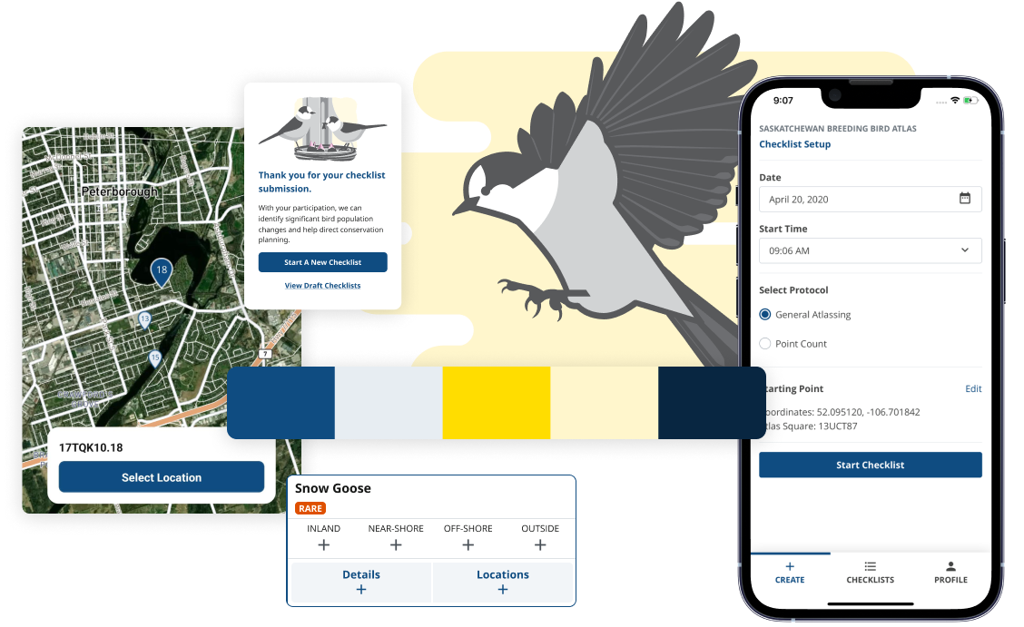
- “Static” protocols—hardcoded research protocols that could not be customized by Birds Canada just yet. General Atlassing and Point Count protocols are the most common birding protocols, so we started with those.
- French and English language support.
- Interacting with the NatureCounts server API.
Starting with a focused MVP helped us get the app built and launched much quicker than if we had waited until all of the features were included, and it also gave us the ability to properly prioritize additional features once we got real feedback from users.
Over the course of the last three years, we have worked on multiple sprints to roll out more sophisticated features:
- Custom research protocols and field types so that the Birds Canada team can create new and custom surveys without the help of our development team.
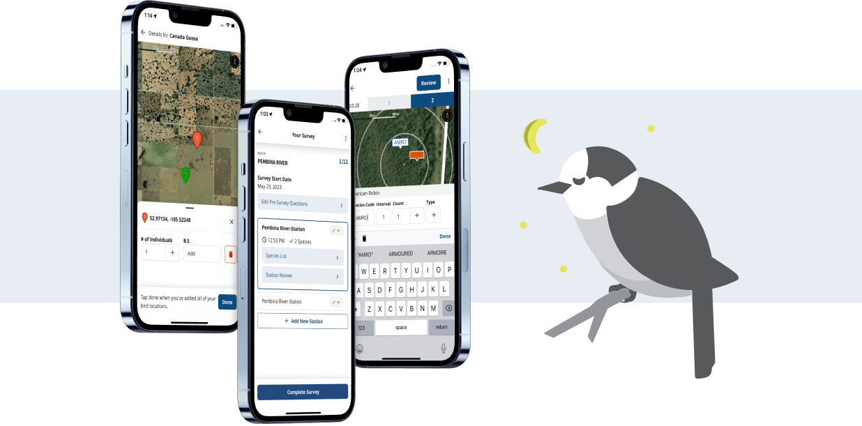
- GPS and location tracking to allow users to drop a location marker on a species to get that species exact location, and to show users where they bird watched (their track).
- Incorporating timers for set duration surveys, with haptic feedback to signal breaks between intervals and the end of a timer.
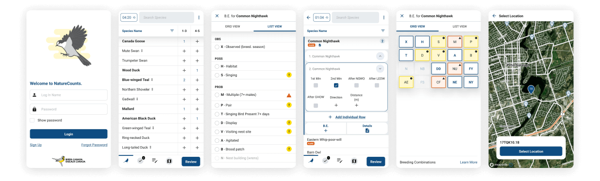
- Flagging rare species and high counts to maintain data integrity.
- Collecting breeding evidence and provide data validation specific to each species’ entered breeding evidence.
- Integrate safe breeding date guidelines to provide users with an understanding of appropriate breeding evidence at the species level.
- Allowing users to download their draft checklists (bird watching list).
- Supporting protocols that allow birding within routes and within those routes are multiple stations.
- Allowing the recording of environmental variables as users go birding.
- Ensure the app has up-to-date birding data based on province, location, time of year, etc..
- Search functionality for users to look up specific species through different search parameters.
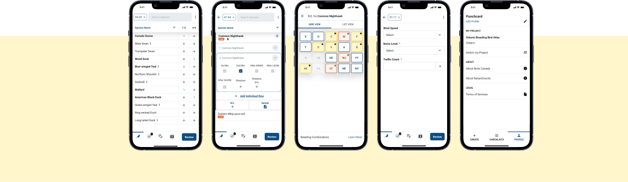
- A point count protocol interface—that allowed tracking time and the distance of a bird’s location based on the user’s location by dropping a pin on a distance grid projected on a satellite map view.
Birding can be extremely intense and fast, so we made continuous UX improvements to make data entry easier and more efficient for users.
All data collected through the mobile application gets contributed to the NatureCounts database, which holds the most extensive source of information on bird populations in Canada. It is one of the largest biodiversity repositories in the world, and provides open access data for hundreds of conservation and research applications.
The mobile application was funded with financial support to Birds Canada from Environment and Climate Change Canada and the RBC Foundation through RBC Tech for Nature.


The outcome
- Enabling citizen scientists and volunteers to input bird data in real-time during birdwatching and providing immediate feedback on the data they entered.
- Easy deployment of new projects and protocols within the app to conduct multiple research projects at the same time, each supporting unique ranges and types of data.
- Collecting GPS tracks to understand the relationship between habitats visited and species reported. Precise location-based data also helps identify endangered and rare species.
- Gather data on species at risk to help inform critical habitat designation and environmental assessment processes.
The app is a game changer for bird research in Canada. It has increased the amount, quality and speed of data collection. Helping us understand ecological changes and advocate for better decisions, faster, as we navigate a global biodiversity and climate crisis.
Catherine Jardine – Data Scientist Technologist
Project by the numbers
400%
increase in submitted checklists111%
more users participating annually500,000+
data records collected7,300
hours of data entry time saved